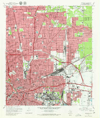
1967 Map of Settegast
USGS Topo · Published 1980About this map
Halls Bayou and Hunting Bayou carve through the urban expansion of northeastern Houston in this mid-century period. The map documents a critical infrastructure era, dominated by the massive rail operations of the Settegast yards and the intricate industrial network surrounding the Turning Basin and Washburn Tunnel. This region was rapidly infilling with residential developments like Sherwood Place and North Shadydale, supported by a dense concentration of civic institutions including the Kashmere Gardens High Sch and St Elizabeth Hospital. The landscape is characterized by its transition from suburban margins to the heavy industrial core, with numerous schools such as Smiley High Sch and Luther Burbank Sch reflecting the post-war population boom. For genealogists, the map provides precise locations for several large burial grounds, including Oak Park Cem and Hollywood Cemetery.
Find a feature on this map
91 named features on this map. Tap any name to fly to it.
Don’t see what you’re looking for? This feature index may not catch every label — zoom into the map to look around manually.
Map Details
Editions of this 1967 Settegast Map
2 editions found
Other maps of this area

1915 · Bellaire
USGS Topo · 1:24,000

1915 · Park Place
USGS Topo · 1:24,000

1915 · Houston Heights
USGS Topo · 1:24,000

1915 · Deepwater
USGS Topo · 1:24,000

1916 · Aldine
USGS Topo · 1:24,000

1916 · Settegast
USGS Topo · 1:24,000

1916 · Fauna
USGS Topo · 1:24,000

1916 · Harmaston
USGS Topo · 1:24,000

1916 · Humble
USGS Topo · 1:24,000

1919 · Aldine
USGS Topo · 1:31,680