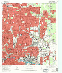
1982 Map of Settegast
USGS Topo · Published 1983About this map
The massive rail infrastructure of East Houston dominates this 1980s landscape, centered on the sprawling rail junctions of the Settegast Yards and Englewood Yards. This area, encompassing the communities of Settegast and Jacinto City, represents a critical industrial artery where the Missouri Pacific and Southern Pacific lines converge. Beyond the heavy industry, the map documents a dense network of mid-century civic life, including numerous schools like Kashmere Gardens High School and specialized institutions such as St Elizabeth Hospital.
Find a feature on this map
71 named features on this map. Tap any name to fly to it.
Don’t see what you’re looking for? This feature index may not catch every label — zoom into the map to look around manually.
Map Details
Editions of this 1982 Settegast Map
2 editions found
Other maps of this area

1915 · Bellaire
USGS Topo · 1:24,000

1915 · Park Place
USGS Topo · 1:24,000

1915 · Houston Heights
USGS Topo · 1:24,000

1915 · Deepwater
USGS Topo · 1:24,000

1916 · Aldine
USGS Topo · 1:24,000

1916 · Settegast
USGS Topo · 1:24,000

1916 · Fauna
USGS Topo · 1:24,000

1916 · Harmaston
USGS Topo · 1:24,000

1916 · Humble
USGS Topo · 1:24,000

1919 · Aldine
USGS Topo · 1:31,680