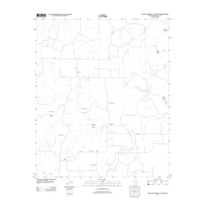
2012 Map of Seven Diamond L Canyon
USGS Topo · Published 2012About this map
Seven Diamond L Canyon and the surrounding Stonewall County terrain reveal a landscape defined by ranching infrastructure and the winding course of the Salt Fork Brazos River. In this 2012 depiction of west Texas, the distribution of Twin Windmills, Patterson Windmill, and Sherrod Windmill underscores the vital role of groundwater management in a region segmented by drainages like Croton Cr and Salt Cr. Settlement patterns are represented by working livestock outposts such as Ellis Pens, North Camp, and Croton Pens. Local history is anchored by the Steele Hill Cem located near the Seven Diamond L Tank. The topographical complexity is highlighted by Pitchfork Canyon in the northeast and numerous hollows, illustrating the eroded breaks that characterize this portion of the Brazos River basin.
Find a feature on this map
29 named features on this map. Tap any name to fly to it.
Don’t see what you’re looking for? This feature index may not catch every label — zoom into the map to look around manually.
Map Details
Editions of this 2012 Seven Diamond L Canyon Map
This is the sole edition of this map. No revisions or reprints were ever made.
Other maps of this area

1954 · Lubbock
USGS Topo · 1:250,000

1958 · Pursley House
USGS Topo · 1:24,000

1958 · Southerland Canyon
USGS Topo · 1:24,000

1958 · Seven Diamond L Canyon
USGS Topo · 1:24,000

1958 · Lovers Resort
USGS Topo · 1:24,000

1958 · Jayton
USGS Topo · 1:24,000

1959 · Bob Creek
USGS Topo · 1:24,000

1968 · Peacock
USGS Topo · 1:24,000
1968 · Swenson
USGS Topo · 1:24,000

1969 · Jayton South
USGS Topo · 1:24,000