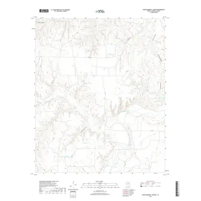
2019 Map of Seven Diamond L Canyon
USGS Topo · Published 2019About this map
The Salt Fork Brazos River carves a winding path through this portion of Stonewall County, defining a landscape of deep drainages and intermittent water sources. This territory is marked by the eponymous Seven Diamond L Canyon and a series of named cattle tanks and small lakes, such as Homer Brinson Lake and Landreth Lake, which reflect the area's ranching heritage. The drainage network is complex, featuring Croton Cr and Salt Croton Cr, alongside numerous canyons including Panther Canyon and Pitchfork Canyon. The sparse road network, including Co RD 350 and C R 340, traces the high ground between the breaks, providing access to remote stock tanks like the Seven-Diamond L Tank and York Tanks. This survey offers a clear view of the hydrologic features and rugged relief that have dictated land use in this part of West Texas for generations.
Find a feature on this map
20 named features on this map. Tap any name to fly to it.
Don’t see what you’re looking for? This feature index may not catch every label — zoom into the map to look around manually.
Map Details
Editions of this 2019 Seven Diamond L Canyon Map
This is the sole edition of this map. No revisions or reprints were ever made.
Other maps of this area

1954 · Lubbock
USGS Topo · 1:250,000

1958 · Pursley House
USGS Topo · 1:24,000

1958 · Southerland Canyon
USGS Topo · 1:24,000

1958 · Seven Diamond L Canyon
USGS Topo · 1:24,000

1958 · Lovers Resort
USGS Topo · 1:24,000

1958 · Jayton
USGS Topo · 1:24,000

1959 · Bob Creek
USGS Topo · 1:24,000

1968 · Peacock
USGS Topo · 1:24,000
1968 · Swenson
USGS Topo · 1:24,000

1969 · Jayton South
USGS Topo · 1:24,000