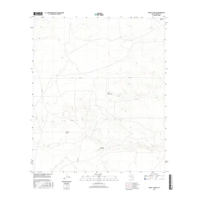
2016 Map of Seven L Peak NE
USGS Topo · Published 2016About this map
Running Water Draw and Virginia Draw carve through the arid high desert of Culberson County, marking the primary drainage patterns for this sparsely settled corner of the Trans-Pecos. The landscape is defined by its seasonal watercourses, including Cedar Pasture Draw and Horseshoe Draw, which provide critical reference points in an otherwise expansive terrain. Transportation is limited to rugged paths like Seven L Rd, illustrating the isolation and ranching-focused land use of the region in the early 21st century. This map offers a clear view of the topographic contours and remote road networks essential for navigating the high-altitude ranch lands near the New Mexico border.
Find a feature on this map
5 named features on this map. Tap any name to fly to it.
Don’t see what you’re looking for? This feature index may not catch every label — zoom into the map to look around manually.
Map Details
Editions of this 2016 Seven L Peak NE Map
This is the sole edition of this map. No revisions or reprints were ever made.
Other maps of this area

1954 · Van Horn
USGS Topo · 1:250,000

1958 · Van Horn
USGS Topo · 1:250,000

1973 · Seven L Peak
USGS Topo · 1:24,000

1973 · Two Mill Draw West
USGS Topo · 1:24,000

1973 · Seven L Peak NE
USGS Topo · 1:24,000

1973 · Rustler Hills
USGS Topo · 1:24,000

1973 · K C Ranch
USGS Topo · 1:24,000

1973 · Screw Bean Draw West
USGS Topo · 1:24,000

1973 · Delaware Spring
USGS Topo · 1:24,000
1973 · Castile Hill
USGS Topo · 1:24,000