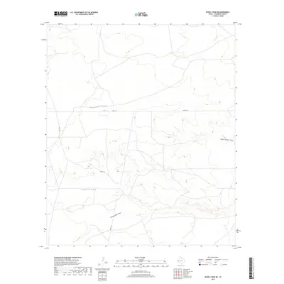
2019 Map of Seven L Peak NE
USGS Topo · Published 2019About this map
Horseshoe Draw and Virginia Draw cut across this high desert landscape in Culberson County, defining a region where water management and topography dictate the placement of local infrastructure. This part of the Trans-Pecos is characterized by its drainage patterns, with significant features like Running Water Draw and Cedar Pasture Draw serving as the primary geographic markers. The sparse road network is anchored by Seven L Rd, which provides access through this arid terrain. The map captures the specialized environmental data of the late 2010s, showing how subtle changes in elevation and dry watercourses organize the land in one of Texas's most open and sparsely populated counties.
Find a feature on this map
5 named features on this map. Tap any name to fly to it.
Don’t see what you’re looking for? This feature index may not catch every label — zoom into the map to look around manually.
Map Details
Editions of this 2019 Seven L Peak NE Map
This is the sole edition of this map. No revisions or reprints were ever made.
Other maps of this area

1954 · Van Horn
USGS Topo · 1:250,000

1958 · Van Horn
USGS Topo · 1:250,000

1973 · Seven L Peak
USGS Topo · 1:24,000

1973 · Two Mill Draw West
USGS Topo · 1:24,000

1973 · Seven L Peak NE
USGS Topo · 1:24,000

1973 · Rustler Hills
USGS Topo · 1:24,000

1973 · K C Ranch
USGS Topo · 1:24,000

1973 · Screw Bean Draw West
USGS Topo · 1:24,000

1973 · Delaware Spring
USGS Topo · 1:24,000
1973 · Castile Hill
USGS Topo · 1:24,000