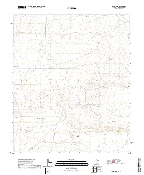
2022 Map of Seven L Peak NE
USGS Topo · Published 2022About this map
Virginia Draw and Running Water Draw carve through the high plains of Culberson County, marking the drainage patterns of this arid landscape. The map showcases a region defined by its wide ephemeral watercourses, including the notable Horseshoe Draw in the northwest and Cedar Pasture Draw to the east. These geological features reveal how water moves through the high desert during infrequent rains, shaping the topography long before modern infrastructure arrived. Human impact on the land is concentrated along Seven L Rd, a primary route that snakes across the terrain, connecting isolated points in this section of West Texas. The sparse distribution of named features underscores the rural character of the area, where land management and ranching navigation rely on these distinct natural landmarks.
Find a feature on this map
5 named features on this map. Tap any name to fly to it.
Don’t see what you’re looking for? This feature index may not catch every label — zoom into the map to look around manually.
Map Details
Editions of this 2022 Seven L Peak NE Map
This is the sole edition of this map. No revisions or reprints were ever made.
Other maps of this area

1954 · Van Horn
USGS Topo · 1:250,000

1958 · Van Horn
USGS Topo · 1:250,000

1973 · Seven L Peak
USGS Topo · 1:24,000

1973 · Two Mill Draw West
USGS Topo · 1:24,000

1973 · Seven L Peak NE
USGS Topo · 1:24,000

1973 · Rustler Hills
USGS Topo · 1:24,000

1973 · K C Ranch
USGS Topo · 1:24,000

1973 · Screw Bean Draw West
USGS Topo · 1:24,000

1973 · Delaware Spring
USGS Topo · 1:24,000
1973 · Castile Hill
USGS Topo · 1:24,000