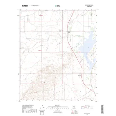
2023 Map of Seven Rivers
USGS Topo · Published 2023About this map
Seven Rivers anchors this arid New Mexico landscape where the high desert meets the hydrologic complexity of the Pecos River valley. The terrain is defined by the prominent Seven Rivers Hills and a network of ephemeral drainages, including the North Seven Rivers, Middle Seven Rivers, and South Seven Rivers, which converge toward the river. This area is notably characterized by its numerous natural water sources, such as Bubbling Spring, Roaring Spring, and the uniquely named Twin Boils Spring. These springs and the Major Johnson Springs group represent critical water points in the Chihuahuan Desert environment. Transportation through the area is facilitated by Seven Rivers Airport and a grid of rural roads like White Pine Rd and Rock Daisy Rd. Downstream, the landscape transitions toward W Brantley Lake Rd, where Willow Draw and Rocky Arroyo carry seasonal runoff toward the river basin.
Find a feature on this map
33 named features on this map. Tap any name to fly to it.
Don’t see what you’re looking for? This feature index may not catch every label — zoom into the map to look around manually.
Map Details
Editions of this 2023 Seven Rivers Map
This is the sole edition of this map. No revisions or reprints were ever made.
Other maps of this area

1940 · Bandanna Point
USGS Topo · 1:62,500

1943 · Bandanna Point
USGS Topo · 1:62,500

1943 · West Carlsbad
USGS Topo · 1:62,500

1945 · West Carlsbad
USGS Topo · 1:62,500

1954 · Seven Rivers
USGS Topo · 1:24,000

1954 · Carlsbad
USGS Topo · 1:250,000

1955 · Dayton
USGS Topo · 1:24,000

1955 · Lake Mc Millan North
USGS Topo · 1:24,000

1955 · Lake Mc Millan South
USGS Topo · 1:24,000

1956 · Parish Ranch
USGS Topo · 1:24,000