
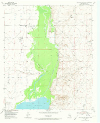
1955 Map of Lake Mc Millan North
USGS Topo · Published 1956About this map
Lake Mc Millan defines the southern extent of this mid-century survey, where the braided waters of the Pecos River transition into a broad reservoir. The landscape is marked by the complex hydrology of the Pecos basin, featuring the Pecos River (Old Channel), the Pecos River (West Channel), and several ephemeral drainage systems like Fourmile Draw and Scoggin Draw. To the west, the A T & S F railroad runs parallel to the river valley, serving the small settlement of Lakewood.
Find a feature on this map
19 named features on this map. Tap any name to fly to it.
Don’t see what you’re looking for? This feature index may not catch every label — zoom into the map to look around manually.
Map Details
Editions of this 1955 Lake Mc Millan North Map
2 editions found
Other maps of this area

1943 · Oil City
USGS Topo · 1:62,500

1954 · Seven Rivers
USGS Topo · 1:24,000

1954 · Carlsbad
USGS Topo · 1:250,000

1955 · Artesia
USGS Topo · 1:24,000

1955 · Spring Lake
USGS Topo · 1:24,000

1955 · Dayton
USGS Topo · 1:24,000

1955 · Lake Mc Millan South
USGS Topo · 1:24,000

1955 · Red Lake
USGS Topo · 1:24,000

1958 · Carlsbad
USGS Topo · 1:250,000

1978 · Artesia
USGS Topo · 1:100,000