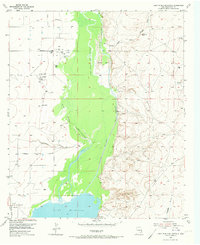
1955 Map of Lake Mc Millan North
USGS Topo · Published 1973About this map
Lake Mc Millan dominates the southern reaches of this mid-century survey, fed by a complex network of channels and draws. The Pecos River is depicted in a state of hydrological transition, featuring a West Channel, a Old Channel, and the artificial Kaiser Channel. This engineering of the river corridor is contrasted by the dry bed of Kaiser Lake and the prominence of Chalk Bluff to the northeast. Settlement is sparse, focused on the community of Lakewood near the southwestern shore and the Lewis Ranch inland. The A T & S F railroad skirts the western edge of the valley, providing a critical transport link through this arid landscape. Numerous windmills, oil tanks, and a Gaging Sta reflect the region's reliance on both water management and emerging mineral extraction. The map also traces significant drainage systems like Rio Peñasco and Fourmile Draw, which define the topography of the surrounding basin.
Find a feature on this map
19 named features on this map. Tap any name to fly to it.
Don’t see what you’re looking for? This feature index may not catch every label — zoom into the map to look around manually.
Map Details
Editions of this 1955 Lake Mc Millan North Map
2 editions found
Other maps of this area

1943 · Oil City
USGS Topo · 1:62,500

1954 · Seven Rivers
USGS Topo · 1:24,000

1954 · Carlsbad
USGS Topo · 1:250,000

1955 · Artesia
USGS Topo · 1:24,000

1955 · Spring Lake
USGS Topo · 1:24,000

1955 · Dayton
USGS Topo · 1:24,000

1955 · Lake Mc Millan North
USGS Topo · 1:24,000

1955 · Lake Mc Millan South
USGS Topo · 1:24,000

1955 · Red Lake
USGS Topo · 1:24,000

1958 · Carlsbad
USGS Topo · 1:250,000