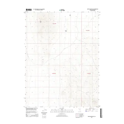
2014 Map of Seven Troughs SE
USGS Topo · Published 2014About this map
The Seven Troughs Range dominates the northwestern corner of this Pershing County landscape, a stark rise above the surrounding basin floor. Located in the high desert of Nevada, this area is characterized by the deep incision of Toll Rock Canyon and the expanse of Sage Valley to the northeast. The terrain reflects the geological transition from rugged mountain slopes to alluvial plains, where the NV-399 highway cuts through the southeastern corner, providing the primary point of access to this remote region. For researchers, the map provides a precise layout of township and range boundaries including t29n r28e and t28n r29e, tracing the public land survey system across an arid environment defined more by its natural landmarks than by human settlement.
Find a feature on this map
8 named features on this map. Tap any name to fly to it.
Don’t see what you’re looking for? This feature index may not catch every label — zoom into the map to look around manually.
Map Details
Editions of this 2014 Seven Troughs SE Map
This is the sole edition of this map. No revisions or reprints were ever made.
Other maps of this area

1931 · Lovelock
USGS Topo · 1:250,000

1935 · Lovelock
USGS Topo · 1:250,000

1955 · Lovelock
USGS Topo · 1:250,000

1956 · Toulon
USGS Topo · 1:62,500

1959 · Lovelock
USGS Topo · 1:250,000
1981 · Bluewing Flat South
USGS Topo · 1:24,000

1981 · Bluewing Flat North
USGS Topo · 1:24,000
1981 · Seven Troughs
USGS Topo · 1:24,000

1981 · Trinity Pass
USGS Topo · 1:24,000
1981 · Trinity Pass NW
USGS Topo · 1:24,000