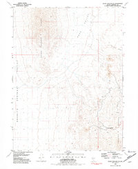
1981 Map of Seven Troughs SE
USGS Topo · Published 1982About this map
The Seven Troughs Range and Trinity Range dominate this desert landscape, framing the expansive drainage basins of Sage Valley and Granite Springs Valley. Compiled from 1974 aerial photography and field checked in the mid-1970s, the map reveals a high concentration of extractive industry concentrated along the eastern slopes. The Eagle Picher Mine stands as the primary landmark in this mineral-rich corridor, surrounded by numerous unnamed Mines and various Prospects scattered across the basin-and-range topography. Topographic detail captures the steep ascent of Toll Rock Canyon and the surrounding ridgelines, illustrating the isolation of these industrial sites within the arid Nevada interior during the early 1980s.
Find a feature on this map
9 named features on this map. Tap any name to fly to it.
Don’t see what you’re looking for? This feature index may not catch every label — zoom into the map to look around manually.
Map Details
Editions of this 1981 Seven Troughs SE Map
This is the sole edition of this map. No revisions or reprints were ever made.
Other maps of this area

1931 · Lovelock
USGS Topo · 1:250,000

1935 · Lovelock
USGS Topo · 1:250,000

1955 · Lovelock
USGS Topo · 1:250,000

1956 · Toulon
USGS Topo · 1:62,500

1959 · Lovelock
USGS Topo · 1:250,000
1981 · Bluewing Flat South
USGS Topo · 1:24,000

1981 · Bluewing Flat North
USGS Topo · 1:24,000
1981 · Seven Troughs
USGS Topo · 1:24,000

1981 · Trinity Pass
USGS Topo · 1:24,000
1981 · Trinity Pass NW
USGS Topo · 1:24,000