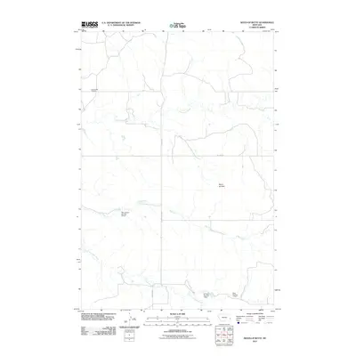
2011 Map of Seven-up Butte
USGS Topo · Published 2011About this map
Lame Jones Cemetery sits in the northwest corner of this Fallon County landscape, marking a site of local genealogical interest within a terrain defined by intermittent waterways and prairie ranching. The map reveals a land managed for water resources, with several small-scale engineering features such as the Palm Ranch Number 2 Dam, Ed Rath Number 1 Dam, and Riley Number 1 Dam situated along the winding drainage of Milk Creek and its southern fork. The prominent landmark of Seven-up Butte rises in the eastern portion of the quadrangle, serving as a distinct physical anchor for the area. A simple network of roads, including Pleyna Rd and Willard Rd, provides the primary access through this rural Montana expanse, tracing the path of early 21st-century settlement and land use.
Find a feature on this map
11 named features on this map. Tap any name to fly to it.
Don’t see what you’re looking for? This feature index may not catch every label — zoom into the map to look around manually.
Map Details
Editions of this 2011 Seven-up Butte Map
This is the sole edition of this map. No revisions or reprints were ever made.
Other maps of this area

1953 · Miles City
USGS Topo · 1:250,000

1957 · Miles City
USGS Topo · 1:250,000

1958 · Miles City
USGS Topo · 1:250,000

1981 · Baker
USGS Topo · 1:100,000

1981 · Harmon Butte
USGS Topo · 1:24,000

1981 · South Sandstone Reservoir
USGS Topo · 1:24,000

1981 · Little Pine Creek
USGS Topo · 1:24,000

1981 · Seven-Up Butte
USGS Topo · 1:24,000
1981 · Sportsman Pond
USGS Topo · 1:24,000
1981 · Medicine Rocks State Park
USGS Topo · 1:24,000