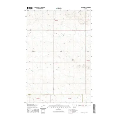
2017 Map of Seven-up Butte
USGS Topo · Published 2017About this map
Seven-up Butte rises above a landscape defined by seasonal watercourses and straight-line section roads in this part of Eastern Montana. The terrain is marked by the presence of the Lame Jones Cem, a significant marker for those tracing early settlement history along Lame Jones Cr. This area of Fallon County and Carter County illustrates a classic western grid of rural roads, including Plevna Rd S and Willard Rd W, which navigate the drainages of Milk Cr and its South Fork. The map provides a clear record of the intersection between the natural hydrology of the Great Plains and the formal boundaries of the Public Land Survey System during the early 21st century.
Find a feature on this map
19 named features on this map. Tap any name to fly to it.
Don’t see what you’re looking for? This feature index may not catch every label — zoom into the map to look around manually.
Map Details
Editions of this 2017 Seven-up Butte Map
This is the sole edition of this map. No revisions or reprints were ever made.
Other maps of this area

1953 · Miles City
USGS Topo · 1:250,000

1957 · Miles City
USGS Topo · 1:250,000

1958 · Miles City
USGS Topo · 1:250,000

1981 · Baker
USGS Topo · 1:100,000

1981 · Harmon Butte
USGS Topo · 1:24,000

1981 · South Sandstone Reservoir
USGS Topo · 1:24,000

1981 · Little Pine Creek
USGS Topo · 1:24,000

1981 · Seven-Up Butte
USGS Topo · 1:24,000
1981 · Sportsman Pond
USGS Topo · 1:24,000
1981 · Medicine Rocks State Park
USGS Topo · 1:24,000