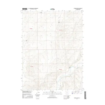
2016 Map of Sevenmile Draw
USGS Topo · Published 2016About this map
The Little Snake River meanders through the southeastern corner of this high-desert landscape in Moffat County, creating a riparian corridor within a region defined by arid drainage patterns and stark relief. To the north, the elevation is anchored by Yellow Cat Butte and the prominent spine of Sevenmile Ridge, which separates the surrounding basins. This territory is characterized by its complex network of seasonal washes and eroded landforms, including the eponymous Sevenmile Draw and Dugout Draw. Transportation through this isolated portion of Colorado relies on a sparse network of county routes such as Co RD 75 and Co RD 21, which follow the natural contours of the ridges and valley floors. The map details the Public Land Survey System divisions, including townships t9n r98w and t8n r97w, providing a precise record of the physical and political boundaries of the area as they appeared in 2016.
Find a feature on this map
13 named features on this map. Tap any name to fly to it.
Don’t see what you’re looking for? This feature index may not catch every label — zoom into the map to look around manually.
Map Details
Editions of this 2016 Sevenmile Draw Map
This is the sole edition of this map. No revisions or reprints were ever made.
Other maps of this area

1954 · Vernal
USGS Topo · 1:250,000

1958 · Vernal
USGS Topo · 1:250,000

1958 · Maybell
USGS Topo · 1:62,500

1960 · Vernal
USGS Topo · 1:250,000

1960 · Lone Mountain
USGS Topo · 1:62,500

1969 · The Nipple
USGS Topo · 1:24,000

1969 · Sheepherder Springs
USGS Topo · 1:24,000
1969 · Lang Spring
USGS Topo · 1:24,000
1979 · Canyon of Lodore
USGS Topo · 1:100,000
1986 · Lone Mountain
USGS Topo · 1:24,000