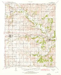
1939 Map of Severy
USGS Topo · Published 1976About this map
Fall River flows through the heart of this landscape, anchoring a rural Kansas community defined by its intricate network of country schools and the convergence of major rail lines. Surveyed in the late 1930s, the area around Severy and Climax showcases a dense distribution of local education hubs such as North Pole Sch, Prairie de Chene Sch, and Batton Sch, reflecting the township-based settlement patterns of the era. The presence of the Atchison Topeka and Santa Fe and San Francisco railroads highlights the region's historical importance as a transit corridor for agricultural goods. From the small settlement of Fiat to the southern reaches of Indian Creek, this survey captures a distinct moment before rural consolidation altered the local social geography, leaving behind specific landmarks like the Honey Creek Bridge and numerous family-named cemeteries.
Find a feature on this map
68 named features on this map. Tap any name to fly to it.
Don’t see what you’re looking for? This feature index may not catch every label — zoom into the map to look around manually.
Map Details
Editions of this 1939 Severy Map
2 editions found

Other maps of this area

1885 · Eureka
USGS Topo · 1:125,000

1885 · Sedan
USGS Topo · 1:125,000

1886 · Fredonia
USGS Topo · 1:125,000

1886 · Independence
USGS Topo · 1:125,000

1888 · Eureka
USGS Topo · 1:125,000

1889 · Sedan
USGS Topo · 1:125,000

1894 · Fredonia
USGS Topo · 1:125,000

1894 · Independence
USGS Topo · 1:125,000

1894 · Eureka
USGS Topo · 1:125,000

1905 · Independence
USGS Topo · 1:125,000