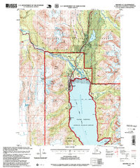
1997 Map of Seward A-7
USGS Topo · Published 1999About this map
The town of Seward serves as the focal point for this late-century coastal survey, situated where the Alaska Railroad and Seward Highway meet the head of Resurrection Bay. This industrial and transit hub is depicted with its aviation and maritime infrastructure, including the Seward Airport and local Comm Towers, alongside educational landmarks like Seward High Sch. The surrounding landscape is a complex network of glacial valleys and alpine peaks, where the Resurrection River flows through a wide alluvial plain north of the city.
Find a feature on this map
62 named features on this map. Tap any name to fly to it.
Don’t see what you’re looking for? This feature index may not catch every label — zoom into the map to look around manually.
Map Details
Editions of this 1997 Seward A-7 Map
This is the sole edition of this map. No revisions or reprints were ever made.
Other maps of this area

1946 · Blying Sound
USGS Topo · 1:250,000

1950 · Seward A-6
USGS Topo · 1:63,360

1950 · Seward A-8
USGS Topo · 1:63,360

1950 · Blying Sound D-7
USGS Topo · 1:63,360

1950 · Blying Sound D-6
USGS Topo · 1:63,360

1950 · Seward A-7
USGS Topo · 1:63,360

1951 · Blying Sound
USGS Topo · 1:250,000

1951 · Seward
USGS Topo · 1:250,000

1951 · Seward A-6
USGS Topo · 1:63,360

1951 · Seward A-7
USGS Topo · 1:63,360