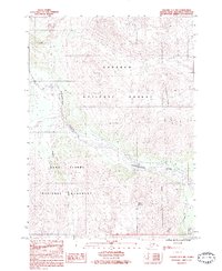
1983 Map of Seward A-7 NW
USGS Topo · Published 1983About this map
Glacial ice and alpine terrain dominate this 1983 survey of the Kenai Peninsula, where the Resurrection River flows through a deep valley between soaring heights. The map documents a significant conservation boundary, showing the northern reaches of the Kenai Fjords National Monument where it meets the Chugach National Forest. To the southeast, the Seward Corporate Boundary edges into the frame near the base of Mount Benson, marking the interface between the growing municipality and the surrounding wilderness. Notable drainage systems like Paradise Creek and Japanese Creek carve through the landscape, while the jagged Resurrection Peaks overlook several unnamed glaciers. This provisional map captures the region's topography just as these federal land designations were being firmly established in the early 1980s.
Find a feature on this map
11 named features on this map. Tap any name to fly to it.
Don’t see what you’re looking for? This feature index may not catch every label — zoom into the map to look around manually.
Map Details
Editions of this 1983 Seward A-7 NW Map
This is the sole edition of this map. No revisions or reprints were ever made.
Other maps of this area

1950 · Seward A-8
USGS Topo · 1:63,360

1950 · Seward A-7
USGS Topo · 1:63,360

1951 · Seward
USGS Topo · 1:250,000

1951 · Seward A-7
USGS Topo · 1:63,360

1951 · Seward B-7
USGS Topo · 1:63,360

1951 · Seward B-8
USGS Topo · 1:63,360

1951 · Seward A-8
USGS Topo · 1:63,360
1952 · Seward A-8
USGS Topo · 1:63,360
1952 · Seward B-8
USGS Topo · 1:63,360

1953 · Seward B-7
USGS Topo · 1:63,360