
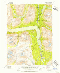
1953 Map of Seward B-7
USGS Topo · Published 1954About this map
Moose Pass and Lawing serve as the primary nodes of human activity in this 1950s survey of the Kenai Peninsula. The landscape is defined by the industrial and transport corridor following the Alaska Railroad and the Sterling Highway, which wind between Upper Trail Lake and the northern reaches of Kenai Lake. This era shows a transition where traditional resource extraction meets early recreation, evidenced by the proximity of Wolf Trail Lodge to established mining operations.
Find a feature on this map
60 named features on this map. Tap any name to fly to it.
Don’t see what you’re looking for? This feature index may not catch every label — zoom into the map to look around manually.
Map Details
Editions of this 1953 Seward B-7 Map
2 editions found
Other maps of this area

1950 · Seward A-6
USGS Topo · 1:63,360

1950 · Seward A-8
USGS Topo · 1:63,360

1950 · Seward A-7
USGS Topo · 1:63,360

1951 · Seward
USGS Topo · 1:250,000

1951 · Seward A-6
USGS Topo · 1:63,360

1951 · Seward A-7
USGS Topo · 1:63,360

1951 · Seward B-7
USGS Topo · 1:63,360

1951 · Seward C-6
USGS Topo · 1:63,360

1951 · Seward B-6
USGS Topo · 1:63,360

1951 · Seward C-8
USGS Topo · 1:63,360