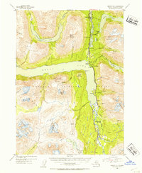
1953 Map of Seward B-7
USGS Topo · Published 1954About this map
Kenai Lake and the Snow River valley anchor this mid-century survey of the Kenai Peninsula, where the Alaska Railroad and the Seward Anchorage Highway parallel the rugged water systems. The landscape is defined by its early industrial and recreational footprint, featuring a notable concentration of mining activity including the Crown Point Mine, Falls Creek Mine, and the Primrose Mine. Local genealogy and land use are preserved through unique markers like the Minnie Andacher Homestead and small settlements such as Muskwa Village and Lawing. The transition from frontier industry to leisure is evident in the presence of the Wolf Trail Lodge and the Divide Ski Area near the southern map edge. Traces of older operations remain, specifically the Solars Sawmill (Abandoned) located north of Grant Lake.
Find a feature on this map
57 named features on this map. Tap any name to fly to it.
Don’t see what you’re looking for? This feature index may not catch every label — zoom into the map to look around manually.
Map Details
Editions of this 1953 Seward B-7 Map
2 editions found

Other maps of this area

1950 · Seward A-6
USGS Topo · 1:63,360

1950 · Seward A-8
USGS Topo · 1:63,360

1950 · Seward A-7
USGS Topo · 1:63,360

1951 · Seward
USGS Topo · 1:250,000

1951 · Seward A-6
USGS Topo · 1:63,360

1951 · Seward A-7
USGS Topo · 1:63,360

1951 · Seward B-7
USGS Topo · 1:63,360

1951 · Seward C-6
USGS Topo · 1:63,360

1951 · Seward B-6
USGS Topo · 1:63,360

1951 · Seward C-8
USGS Topo · 1:63,360