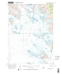
1951 Map of Seward A-8
USGS Topo · Published 1997About this map
The Harding Ice Field dominates the high-altitude landscape of this 1951 survey, serving as the source for several massive glacial systems in the southern Kenai Mountains. This map documents the complex glacial geography of the era, where the Lowell Glacier and Bear Glacier flow outward from the ice field's edge, marked by numerous crevasses and dramatic elevation changes. In the northeast corner, the Resurrection River basin provides a corridor for several smaller tributaries, including Cottonwood Creek and Placer Creek, before they exit the Chugach National Forest. The western half of the sheet is largely defined by the Kenai National Moose Range, illustrating the early 1950s boundaries of this protected wilderness. Because the topography was mapped primarily from 1950 aerial photographs, it offers a precise record of glacial extents and drainage patterns prior to later twentieth-century environmental shifts.
Find a feature on this map
15 named features on this map. Tap any name to fly to it.
Don’t see what you’re looking for? This feature index may not catch every label — zoom into the map to look around manually.
Map Details
Editions of this 1951 Seward A-8 Map
4 editions found

Other maps of this area

1944 · Kenai
USGS Topo · 1:250,000

1946 · Blying Sound
USGS Topo · 1:250,000

1950 · Kenai
USGS Topo · 1:250,000

1950 · Kenai B-1
USGS Topo · 1:63,360

1950 · Seward A-8
USGS Topo · 1:63,360

1950 · Blying Sound D-7
USGS Topo · 1:63,360

1950 · Seward A-7
USGS Topo · 1:63,360

1951 · Blying Sound
USGS Topo · 1:250,000

1951 · Seward
USGS Topo · 1:250,000

1951 · Seldovia
USGS Topo · 1:250,000