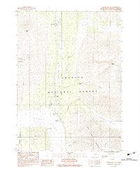
1983 Map of Seward B-7 NE
USGS Topo · Published 1983About this map
Moose Pass serves as a primary point of reference in this high-altitude landscape of the Kenai Peninsula. The settlement pattern follows the narrow corridor between the towering peaks of the Chugach National Forest and a series of interconnected water bodies, including Upper Trail Lake and Lower Trail Lake. The presence of a Landing Strip and Radio Tower near Crown Point indicates the importance of communication and aerial access in this isolated environment.
Find a feature on this map
26 named features on this map. Tap any name to fly to it.
Don’t see what you’re looking for? This feature index may not catch every label — zoom into the map to look around manually.
Map Details
Editions of this 1983 Seward B-7 NE Map
This is the sole edition of this map. No revisions or reprints were ever made.
Other maps of this area

1951 · Seward
USGS Topo · 1:250,000

1951 · Seward B-7
USGS Topo · 1:63,360

1951 · Seward C-6
USGS Topo · 1:63,360

1951 · Seward B-6
USGS Topo · 1:63,360

1951 · Seward C-7
USGS Topo · 1:63,360

1952 · Seward B-6
USGS Topo · 1:63,360

1952 · Seward C-6
USGS Topo · 1:63,360

1953 · Seward C-7
USGS Topo · 1:63,360

1953 · Seward B-7
USGS Topo · 1:63,360

1953 · Seward
USGS Topo · 1:250,000