
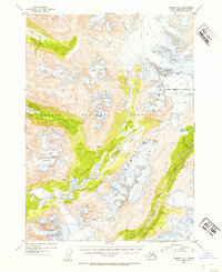
1952 Map of Seward B-6
USGS Topo · Published 1954About this map
The Kenai Mountains dominate this 1952 topographic study, showcasing a landscape defined by massive ice fields and the drainages they feed. Within the Chugach National Forest, the Mother Goose Glacier and the Ellsworth Glacier sit amidst high peaks, with numerous crevasses marked across the upper elevations. This document provides an essential record of the glacial extent before mid-century shifts, showing how the Snow River and Nellie Juan River systems carved deep valleys through the range.
Find a feature on this map
25 named features on this map. Tap any name to fly to it.
Don’t see what you’re looking for? This feature index may not catch every label — zoom into the map to look around manually.
Map Details
Editions of this 1952 Seward B-6 Map
2 editions found
Other maps of this area

1950 · Seward A-6
USGS Topo · 1:63,360

1950 · Seward A-7
USGS Topo · 1:63,360

1951 · Seward
USGS Topo · 1:250,000

1951 · Seward A-6
USGS Topo · 1:63,360

1951 · Seward A-7
USGS Topo · 1:63,360

1951 · Seward B-7
USGS Topo · 1:63,360

1951 · Seward C-6
USGS Topo · 1:63,360

1951 · Seward C-5
USGS Topo · 1:63,360

1951 · Seward A-5
USGS Topo · 1:63,360

1951 · Seward B-6
USGS Topo · 1:63,360