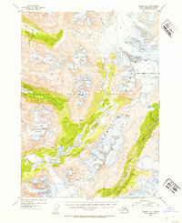
1952 Map of Seward B-6
USGS Topo · Published 1954About this map
The Kenai Mountains dominate this 1950s landscape, where the ice and elevation of the Chugach National Forest dictated movement and seasonal habitation. In the high backcountry, a cluster of Cabins sits on the northern shore of Grant Lake, representing the sparse human footprint in this wilderness during the mid-century era. Access through the difficult terrain was limited to established routes such as the Ptarmigan Lake Trail and the Paradise Valley Trail, which tracked the low ground between massive ice fields.
Find a feature on this map
25 named features on this map. Tap any name to fly to it.
Don’t see what you’re looking for? This feature index may not catch every label — zoom into the map to look around manually.
Map Details
Editions of this 1952 Seward B-6 Map
2 editions found

Other maps of this area

1950 · Seward A-6
USGS Topo · 1:63,360

1950 · Seward A-7
USGS Topo · 1:63,360

1951 · Seward
USGS Topo · 1:250,000

1951 · Seward A-6
USGS Topo · 1:63,360

1951 · Seward A-7
USGS Topo · 1:63,360

1951 · Seward B-7
USGS Topo · 1:63,360

1951 · Seward C-6
USGS Topo · 1:63,360

1951 · Seward C-5
USGS Topo · 1:63,360

1951 · Seward A-5
USGS Topo · 1:63,360

1951 · Seward B-6
USGS Topo · 1:63,360