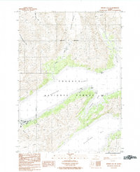
1984 Map of Seward D-5 SE
USGS Topo · Published 1984About this map
Whittier serves as the primary coastal anchor in this 1984 survey of the western Prince William Sound region. Positioned at the head of Passage Canal, the settlement is defined by its strategic marine access and the immense ice masses that surround it. The landscape is dominated by the Chugach National Forest, where heavy glaciation from the Whittier Glacier, Billings Glacier, and Lowell Glacier feeds a network of steep drainages including the South Fork Upper Carmen River and Whittier Creek.
Find a feature on this map
23 named features on this map. Tap any name to fly to it.
Don’t see what you’re looking for? This feature index may not catch every label — zoom into the map to look around manually.
Map Details
Editions of this 1984 Seward D-5 SE Map
This is the sole edition of this map. No revisions or reprints were ever made.
Other maps of this area

1951 · Seward
USGS Topo · 1:250,000

1951 · Seward D-5
USGS Topo · 1:63,360

1951 · Seward C-5
USGS Topo · 1:63,360

1951 · Seward D-4
USGS Topo · 1:63,360

1951 · Seward C-4
USGS Topo · 1:63,360

1952 · Seward D-5
USGS Topo · 1:63,360

1952 · Seward D-4
USGS Topo · 1:63,360

1952 · Seward C-5
USGS Topo · 1:63,360

1952 · Seward C-4
USGS Topo · 1:63,360

1953 · Seward
USGS Topo · 1:250,000