
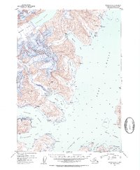
1952 Map of Seward D-4
USGS Topo · Published 1954About this map
Harriman Fiord and the surrounding glacial reaches of the Chugach National Forest define this coastal survey, where ice and sea meet along the intricate shoreline of Port Wells. In the early 1950s, the region supported scattered industrial and maritime activity, evidenced by the Granite Mine near Harrison Lagoon and the Lansing Mine perched above Bettles Bay. These resource extraction points are joined by smaller Cabins and a Logging Camp Bay tucked into the western inlets. Navigation through the deep fjords was aided by the Pt Pigot Light, a critical marker for vessels moving between Passage Canal and Wells Passage. Massive ice flows like Roaring Glacier, Bettles Glacier, and Pigot Glacier dominate the high terrain, descending toward the water and shaping the deep-water access that characterized this era of Prince William Sound history.
Find a feature on this map
55 named features on this map. Tap any name to fly to it.
Don’t see what you’re looking for? This feature index may not catch every label — zoom into the map to look around manually.
Map Details
Editions of this 1952 Seward D-4 Map
2 editions found
Other maps of this area

1951 · Seward
USGS Topo · 1:250,000

1951 · Anchorage
USGS Topo · 1:250,000

1951 · Seward D-5
USGS Topo · 1:63,360

1951 · Seward C-5
USGS Topo · 1:63,360

1951 · Seward D-4
USGS Topo · 1:63,360

1951 · Seward D-3
USGS Topo · 1:63,360

1951 · Seward C-4
USGS Topo · 1:63,360

1951 · Seward C-3
USGS Topo · 1:63,360

1952 · Seward D-5
USGS Topo · 1:63,360

1952 · Seward D-3
USGS Topo · 1:63,360