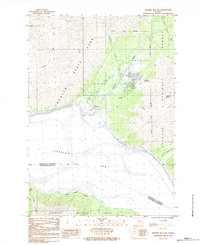
1984 Map of Seward D-6 Nw
USGS Topo · Published 1984About this map
Girdwood and the nearby community of Alyeska sit at the intersection of steep mountain terrain and the tidal mudflats of the Turnagain Arm. Recorded in the early 1980s, this landscape shows the developed footprints of these mountain settlements where Glacier Creek meets the coast. The map illustrates a high degree of topographic variation, transitioning from the sea-level flats to the high elevations of Chugach State Park and Chugach National Forest.
Find a feature on this map
18 named features on this map. Tap any name to fly to it.
Don’t see what you’re looking for? This feature index may not catch every label — zoom into the map to look around manually.
Map Details
Editions of this 1984 Seward D-6 Nw Map
This is the sole edition of this map. No revisions or reprints were ever made.
Other maps of this area

1951 · Seward
USGS Topo · 1:250,000

1951 · Anchorage
USGS Topo · 1:250,000

1951 · Seward D-7
USGS Topo · 1:63,360

1951 · Seward D-6
USGS Topo · 1:63,360

1952 · Seward D-6
USGS Topo · 1:63,360

1952 · Seward D-7
USGS Topo · 1:63,360

1953 · Seward
USGS Topo · 1:250,000

1959 · Seward
USGS Topo · 1:250,000

1960 · Anchorage A-6
USGS Topo · 1:63,360

1960 · Anchorage A-7
USGS Topo · 1:63,360