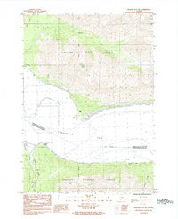
1984 Map of Seward D-7 NE
USGS Topo · Published 1984About this map
Turnagain Arm dominates this mid-1980s Alaskan landscape, defining the coastal boundary where the Municipality of Anchorage Kenai Peninsula Borough line crosses the water. To the north, the small settlement of Bird and the shoreline at Bird Point sit at the base of the steep coastal slopes within Chugach State Park. The map details the drainage of Bird Creek and Penguin Creek as they descend toward the tidal flats, marked by expansive areas of mud.
Find a feature on this map
23 named features on this map. Tap any name to fly to it.
Don’t see what you’re looking for? This feature index may not catch every label — zoom into the map to look around manually.
Map Details
Editions of this 1984 Seward D-7 NE Map
This is the sole edition of this map. No revisions or reprints were ever made.
Other maps of this area

1951 · Seward
USGS Topo · 1:250,000

1951 · Anchorage
USGS Topo · 1:250,000

1951 · Seward D-7
USGS Topo · 1:63,360

1951 · Seward D-6
USGS Topo · 1:63,360

1952 · Seward D-6
USGS Topo · 1:63,360

1952 · Seward D-7
USGS Topo · 1:63,360

1953 · Seward
USGS Topo · 1:250,000

1959 · Seward
USGS Topo · 1:250,000

1960 · Anchorage A-6
USGS Topo · 1:63,360

1960 · Anchorage A-7
USGS Topo · 1:63,360