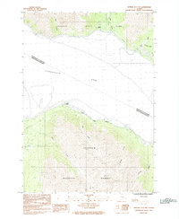
1984 Map of Seward D-7 NW
USGS Topo · Published 1984About this map
Turnagain Arm dominates the center of this mid-1980s survey, illustrating the narrow corridor where human infrastructure meets the coastal wilderness of the Kenai Peninsula. The settlements of Indian and Bird are positioned along the northern shore, where the RR Br and local roads navigate the tight margins between the water and the rising peaks of Chugach State Park. South across the arm, the landscape shifts into the protected expanse of Chugach National Forest, defined by a series of drainage systems including Bear Creek, Sunset Creek, and Sunrise Creek. The map records a specific era of transit and land management, marked by the National Forest Boundary and the prominent landmark of Windy Point, which serves as a navigational reference along the coastal bend.
Find a feature on this map
17 named features on this map. Tap any name to fly to it.
Don’t see what you’re looking for? This feature index may not catch every label — zoom into the map to look around manually.
Map Details
Editions of this 1984 Seward D-7 NW Map
This is the sole edition of this map. No revisions or reprints were ever made.
Other maps of this area

1951 · Seward
USGS Topo · 1:250,000

1951 · Anchorage
USGS Topo · 1:250,000

1951 · Seward D-8
USGS Topo · 1:63,360

1951 · Seward D-7
USGS Topo · 1:63,360

1952 · Seward D-8
USGS Topo · 1:63,360

1952 · Seward D-7
USGS Topo · 1:63,360

1952 · Anchorage A-8
USGS Topo · 1:63,360

1953 · Anchorage A-8
USGS Topo · 1:63,360

1953 · Seward
USGS Topo · 1:250,000

1959 · Seward
USGS Topo · 1:250,000