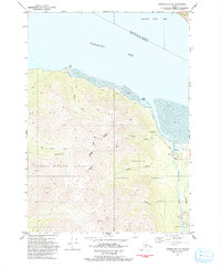
1993 Map of Seward D-8 NE
USGS Topo · Published 1993About this map
Hope stands as a focal point of human activity along the southern shores of Turnagain Arm, where the town's legacy is preserved within a designated National Historic District. This early 1990s landscape illustrates a complex overlap of protected lands and resource extraction, with the boundaries of the Kenai National Wildlife Refuge and Chugach National Forest meeting amidst active mining operations. Along Resurrection Creek, evidence of industry remains clear through labels for a mine, tailings, and various prospects, signaling the area's continued connection to its gold-rush roots. The terrain is marked by steep ridges and drainages like Cripple Creek and Wildhorse Creek, while the Gull Rock Trail skirts the northern coastline toward Gull Rock. This map captures a moment when recreation at Porcupine Campground and conservation efforts coexisted with the physical remnants of the region's mining heritage.
Find a feature on this map
25 named features on this map. Tap any name to fly to it.
Don’t see what you’re looking for? This feature index may not catch every label — zoom into the map to look around manually.
Map Details
Editions of this 1993 Seward D-8 NE Map
This is the sole edition of this map. No revisions or reprints were ever made.
Other maps of this area

1951 · Seward
USGS Topo · 1:250,000

1951 · Anchorage
USGS Topo · 1:250,000

1951 · Seward D-8
USGS Topo · 1:63,360

1951 · Seward D-7
USGS Topo · 1:63,360

1952 · Seward D-8
USGS Topo · 1:63,360

1952 · Seward D-7
USGS Topo · 1:63,360

1952 · Anchorage A-8
USGS Topo · 1:63,360

1953 · Anchorage A-8
USGS Topo · 1:63,360

1953 · Seward
USGS Topo · 1:250,000

1959 · Seward
USGS Topo · 1:250,000