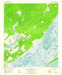
1959 Map of Sewee Bay
USGS Topo · Published 1960About this map
Francis Marion National Forest dominates the inland landscape of this 1950s coastal survey, giving way to the intricate salt marshes and tidal channels of Sewee Bay. The intersection of terrestrial and maritime life is evident along the Ocean Highway, where local community hubs like Awendaw Ch and Awendaw Sch provided foundations for rural residents. Historic burial grounds and places of worship, including Wappetaw Cem, Sewee Ch, and Nebo Ch, are scattered near the transition from forest to marsh. Further south, the Wando River meanders toward the coast, passing small settlements such as Woodville and Chandler. The eastern reaches transition into the protected habitats of the Cape Romain National Wildlife Refuge, featuring a complex network of waterways like Bull Creek and Price Creek that separate Bull Island from the South Carolina mainland.
Find a feature on this map
44 named features on this map. Tap any name to fly to it.
Don’t see what you’re looking for? This feature index may not catch every label — zoom into the map to look around manually.
Map Details
Editions of this 1959 Sewee Bay Map
4 editions found
Other maps of this area

1919 · Capers Island
USGS Topo · 1:21,120

1919 · Wando
USGS Topo · 1:21,120

1919 · Cordesville
USGS Topo · 1:48,000

1919 · Fort Moultrie
USGS Topo · 1:21,120

1919 · Bulls Island
USGS Topo · 1:21,120

1919 · Sewee Bay
USGS Topo · 1:21,120

1943 · Capers Island
USGS Topo · 1:24,000

1943 · Fort Moultrie
USGS Topo · 1:24,000

1943 · Wando
USGS Topo · 1:24,000

1943 · Sewee Bay
USGS Topo · 1:24,000