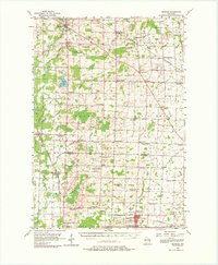
1955 Map of Seymour
USGS Topo · Published 1980About this map
The rural dairy and farm landscape north of Seymour is defined by a dense network of one-room schoolhouses, many of which had already fallen out of use by the mid-1950s. The presence of multiple sites like Sohr Sch, Mapleview Sch, and Oak Leaf Sch reflects the consolidation of local education districts during this era. Small crossroads settlements like Slab City, Landstad, and Briarton anchor the township grid, while the Chicago and North Western and Green Bay and Western railroads provide the vital industrial links for the region's agricultural output. Religious life is marked by country parishes such as Zion Ch and St Johns Ch, often situated near family-named landmarks and the numerous Gravel Pits that dot the terrain near the Shioc and Pensaukee rivers.
Find a feature on this map
74 named features on this map. Tap any name to fly to it.
Don’t see what you’re looking for? This feature index may not catch every label — zoom into the map to look around manually.
Map Details
Editions of this 1955 Seymour Map
3 editions found
Other maps of this area

1954 · De Pere
USGS Topo · 1:62,500

1954 · Shawano
USGS Topo · 1:48,000

1954 · Green Bay
USGS Topo · 1:62,500

1955 · Embarrass
USGS Topo · 1:48,000

1955 · Appleton
USGS Topo · 1:62,500

1955 · Seymour
USGS Topo · 1:62,500

1955 · Green Bay
USGS Topo · 1:250,000

1956 · Gillett
USGS Topo · 1:62,500

1956 · New London
USGS Topo · 1:48,000

1956 · Oconto Falls
USGS Topo · 1:62,500