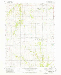
1979 Map of Seymour West
USGS Topo · Published 1980About this map
The agrarian landscape of Wayne County is defined by a dense network of watercourses and intersecting rail lines during the late 1970s. The northern reaches are dominated by South Fork Corydon Creek, Walnut Creek, and Jackson Creek, while the southern townships of Howard and Monroe are drained by Locust Creek. Transportation history is clearly legible here, as the east-west corridor of the Chicago Milwaukee St Paul and Pacific meets the Chicago Rock Island and Pacific near the town of Seymour. Evidence of earlier infrastructure remains visible via the Old RR Gr south of Promise City. Local history researchers will find several family and community landmarks, including the Bollman Cem and Tharp Cem, which are preserved alongside a municipal City Reservoir and various service lines like the cross-country Pipeline.
Find a feature on this map
20 named features on this map. Tap any name to fly to it.
Don’t see what you’re looking for? This feature index may not catch every label — zoom into the map to look around manually.
Map Details
Editions of this 1979 Seymour West Map
This is the sole edition of this map. No revisions or reprints were ever made.
Other maps of this area

1934 · Humeston
USGS Topo · 1:48,000

1935 · Russell
USGS Topo · 1:62,500

1937 · Corydon
USGS Topo · 1:62,500

1938 · Russell
USGS Topo · 1:62,500

1942 · Seymour
USGS Topo · 1:62,500

1944 · Seymour
USGS Topo · 1:62,500

1954 · Centerville
USGS Topo · 1:250,000

1957 · Centerville
USGS Topo · 1:250,000

1958 · Centerville
USGS Topo · 1:250,000

1964 · Allerton
USGS Topo · 1:24,000