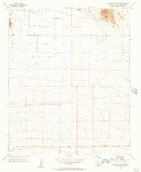
1955 Map of Shadow Mountains SE
USGS Topo · Published 1957About this map
El Mirage Field stands as a primary landmark in the high desert, positioned northwest of the prominent Shadow Mtns. This mid-century survey documents a landscape of alluvial fans and dry lake beds, most notably the expanse of El Mirage Lake situated north of El Mirage Valley. The map detail reveals the emerging network of desert transit, with El Mirage Road and Palmdale Road providing regional connection while smaller arteries like Tanner Road and Old Phelan Road define the local grid. To the west, the elevation rises toward Gray Mtn, contrasting the flat, arid basin that dominates the central portion of the quadrangle. This period represents a time when the region's character was defined by wide-open spaces, limited water resources like the singular Reservoir, and the strategic utility of its dry lakebeds.
Find a feature on this map
15 named features on this map. Tap any name to fly to it.
Don’t see what you’re looking for? This feature index may not catch every label — zoom into the map to look around manually.
Map Details
Editions of this 1955 Shadow Mountains SE Map
4 editions found
Other maps of this area

1901 · Southern California Sheet No. 1
USGS Topo · 1:250,000

1902 · Hesperia
USGS Topo · 1:62,500

1903 · San Antonio
USGS Topo · 1:62,500

1904 · Southern California Sheet No. 1
USGS Topo · 1:250,000

1930 · El Mirage
USGS Topo · 1:24,000

1930 · Angle
USGS Topo · 1:24,000

1932 · Angle
USGS Topo · 1:24,000

1932 · Barstow
USGS Topo · 1:125,000

1933 · El Mirage
USGS Topo · 1:24,000

1934 · Barstow
USGS Topo · 1:125,000