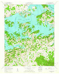
1961 Map of Shady Grove
USGS Topo · Published 1963About this map
Douglas Lake dominates the landscape of this 1961 revision, where the impounded waters of the French Broad River create a complex shoreline of inlets and islands such as Old Egypt. The map documents a rural transition as the Tennessee Valley Authority's influence reshapes the topography of Jefferson and Sevier Counties. While new lakeside landmarks like Lakefront Dock and Weaver Dock appear along the water's edge, the upland ridges preserve an older social fabric of family names and small congregations. Dozens of family burial grounds and community landmarks are recorded here, including Derrick Cemetery, Allen Cemetery, and Jones Chapel. From the heights of English Mountain in the south to the small settlement at Shady Grove in the northwest, the map provides a clear look at the region's mid-century landscape of small churches, schoolhouses like New Center School, and numerous named hollows.
Find a feature on this map
61 named features on this map. Tap any name to fly to it.
Don’t see what you’re looking for? This feature index may not catch every label — zoom into the map to look around manually.
Map Details
Editions of this 1961 Shady Grove Map
2 editions found
Other maps of this area

1883 · Morristown
USGS Topo · 1:125,000

1886 · Knoxville
USGS Topo · 1:125,000

1892 · Knoxville
USGS Topo · 1:125,000

1893 · Mt Guyot
USGS Topo · 1:125,000

1893 · Morristown
USGS Topo · 1:125,000

1894 · Knoxville
USGS Topo · 1:125,000

1895 · Morristown
USGS Topo · 1:125,000

1895 · Knoxville
USGS Topo · 1:125,000

1897 · Maynardville
USGS Topo · 1:125,000

1900 · Maynardville
USGS Topo · 1:125,000