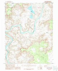
1987 Map of Shafer Basin
USGS Topo · Published 1987About this map
The Colorado River carves a deep, winding path through this corner of San Juan County, defining a landscape of dramatic vertical relief and industrial utility. In the late 20th century, the presence of Salt Evaporators in the Shafer Basin provides a striking contrast to the surrounding protected lands. These man-made ponds sit just north of the border between Dead Horse Point State Park and Canyonlands National Park, illustrating the complex management of Utah's canyon country where potash extraction and conservation coexist. The terrain is further detailed by numerous survey points and topographical landmarks like Pyramid Butte and the sharp turn at Goose Neck. High vantage points such as Canyonlands Overlook and Anticline Overlook provide orientation across the expansive Hatch Point plateau, while scattered signs of mineral exploration, including an Adit and several Prospect sites, dot the high mesas.
Find a feature on this map
16 named features on this map. Tap any name to fly to it.
Don’t see what you’re looking for? This feature index may not catch every label — zoom into the map to look around manually.
Map Details
Editions of this 1987 Shafer Basin Map
2 editions found
Other maps of this area

1885 · La Sal
USGS Topo · 1:250,000

1951 · The Knoll
USGS Topo · 1:62,500

1951 · Upheaval Dome
USGS Topo · 1:62,500

1952 · Carlisle 2 SE
USGS Topo · 1:24,000

1952 · Moab 3 SE
USGS Topo · 1:24,000

1952 · Carlisle 2 NE
USGS Topo · 1:24,000

1952 · Moab 4 SW
USGS Topo · 1:24,000

1954 · Carlisle 1 NE
USGS Topo · 1:24,000

1954 · Carlisle 1 SE
USGS Topo · 1:24,000

1954 · Carlisle 1 NW
USGS Topo · 1:24,000