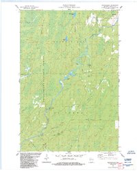
1984 Map of Shanagolden
USGS Topo · Published 1984About this map
The East Fork Chippewa River meanders through the heart of the Chequamegon National Forest in this 1984 survey of the Wisconsin Northwoods. The settlement of Shanagolden sits in the northeast corner, serving as a gateway to a landscape defined by its glacial hydrology and dense timber. The map details a complex network of wetlands and minor tributaries like Kenyon Run and Rocky Run, which feed into the primary river system. This era reflects a transition toward recreational land use, evidenced by the Stock Farm Bridge Recreation Site and numerous public access points at water bodies like Pelican Lake. Local industry is represented by a Gravel Pit near Hungry Run, while named forest tracks such as Mertig Road and Bear Lake Road provide the only significant terrestrial access to this heavily forested terrain.
Find a feature on this map
30 named features on this map. Tap any name to fly to it.
Don’t see what you’re looking for? This feature index may not catch every label — zoom into the map to look around manually.
Map Details
Editions of this 1984 Shanagolden Map
2 editions found
Other maps of this area

1941 · Kennedy
USGS Topo · 1:48,000

1942 · Glidden
USGS Topo · 1:48,000

1942 · Clam Lake
USGS Topo · 1:48,000

1944 · Draper
USGS Topo · 1:48,000

1945 · Kennedy
USGS Topo · 1:48,000

1945 · Clam Lake
USGS Topo · 1:48,000

1945 · Glidden
USGS Topo · 1:48,000

1947 · Draper
USGS Topo · 1:48,000

1953 · Ashland
USGS Topo · 1:250,000

1953 · Rice Lake
USGS Topo · 1:250,000