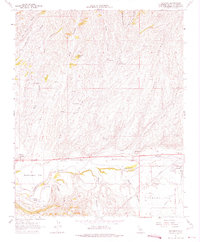
1961 Map of Shandon
USGS Topo · Published 1975About this map
Shandon serves as the focal point of this central California landscape, situated where the Estrella River winds across Shandon Flat. The map reveals a region defined by complex drainage patterns, with numerous deep canyons including Clarke Canyon, Shimmin Canyon, and McMillan Canyon cutting through the terrain toward the river valley. The agricultural and ranching character of the area is evident in the scattered settlements of Whitley Gardens and Gruenhagen Flat, alongside infrastructure like Truesdale Road and a network of pipelines. Water remains a critical element for the territory, documented through numerous named sources such as Morgenson Springs, West Tuley Springs, and Pear Spring. Local community life is anchored by Clark Memorial Park and a Fire Control Station near the town center, while a small Airstrip to the west suggests the era's reliance on private aviation for navigating this expansive terrain.
Find a feature on this map
40 named features on this map. Tap any name to fly to it.
Don’t see what you’re looking for? This feature index may not catch every label — zoom into the map to look around manually.
Map Details
Editions of this 1961 Shandon Map
3 editions found
Other maps of this area

1914 · Cholame
USGS Topo · 1:125,000

1915 · Cholame
USGS Topo · 1:125,000

1917 · Cholame
USGS Topo · 1:125,000

1919 · San Miguel
USGS Topo · 1:62,500

1919 · Paso Robles
USGS Topo · 1:62,500

1943 · Shandon
USGS Topo · 1:31,680

1943 · Paso Robles
USGS Topo · 1:62,500

1943 · Commatti Canyon
USGS Topo · 1:31,680
1943 · Cholame
USGS Topo · 1:31,680

1943 · Shedd Canyon
USGS Topo · 1:31,680