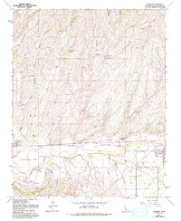
1961 Map of Shandon
USGS Topo · Published 1993About this map
The Estrella River defines the lower drainage of this Central Coast landscape, where the town of Shandon sits at the convergence of several major watercourses and agricultural flats. The map details a complex network of canyons to the north, including Wild Horse Canyon and McMillan Canyon, which feed into the wider Shandon Valley. Settlement patterns are concentrated along the riverbanks and the western edge at Whitley Gardens, revealing the importance of water access in this arid terrain. Numerous perennial sources like Pear Spring, Morgenson Springs, and the dual West Tuley Springs and East Tuley Springs are scattered throughout the hills, marking critical points for early ranching and land use. The topography is further characterized by distinct landmarks such as Murphy Hill and the broad Gruenhagen Flat, while the eastern valley is crisscrossed by established routes including Truesdale Rd and Starkey Road.
Find a feature on this map
32 named features on this map. Tap any name to fly to it.
Don’t see what you’re looking for? This feature index may not catch every label — zoom into the map to look around manually.
Map Details
Editions of this 1961 Shandon Map
3 editions found
Other maps of this area

1914 · Cholame
USGS Topo · 1:125,000

1915 · Cholame
USGS Topo · 1:125,000

1917 · Cholame
USGS Topo · 1:125,000

1919 · San Miguel
USGS Topo · 1:62,500

1919 · Paso Robles
USGS Topo · 1:62,500

1943 · Shandon
USGS Topo · 1:31,680

1943 · Paso Robles
USGS Topo · 1:62,500

1943 · Commatti Canyon
USGS Topo · 1:31,680
1943 · Cholame
USGS Topo · 1:31,680

1943 · Shedd Canyon
USGS Topo · 1:31,680