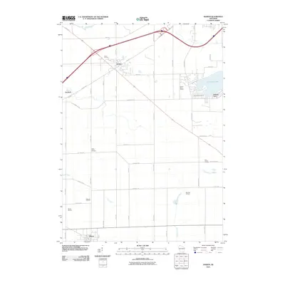
2010 Map of Sharon
USGS Topo · Published 2010About this map
Sharon and Darien anchor this southern Wisconsin landscape in the first decade of the 2000s, where traditional agricultural grids are increasingly punctuated by private aviation and recreation. The village of Sharon sits at the southern edge, its street grid organized near the intersection of Bollinger Rd and Highway 67. To the north, Darien occupies the junction of major transit corridors, surrounded by historical burial grounds such as Darien Cemetery and North Sharon Cemetery.
Find a feature on this map
46 named features on this map. Tap any name to fly to it.
Don’t see what you’re looking for? This feature index may not catch every label — zoom into the map to look around manually.
Map Details
Editions of this 2010 Sharon Map
This is the sole edition of this map. No revisions or reprints were ever made.
Other maps of this area

1893 · Delavan
USGS Topo · 1:62,500

1893 · Shopiere
USGS Topo · 1:62,500

1918 · Belvidere
USGS Topo · 1:62,500

1932 · Harvard
USGS Topo · 1:48,000

1937 · Harvard
USGS Topo · 1:62,500

1944 · Belvidere
USGS Topo · 1:62,500

1954 · Rockford
USGS Topo · 1:250,000

1955 · Rockford
USGS Topo · 1:250,000

1958 · Rockford
USGS Topo · 1:250,000
1960 · Delavan
USGS Topo · 1:62,500