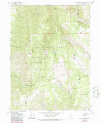
1964 Map of Sharp Mountain
USGS Topo · Published 1986About this map
Sharp Mountain rises as a central landmark within the high terrain of the Wasatch Cache National Forest, where the headwaters of several major drainage systems converge. This 1960s survey, updated in the mid-1980s, highlights a landscape defined by its complex hydrology and early industrial traces. Evidence of mineral exploration is preserved at the La Plata Mine located within La Plata Canyon, north of the Right Fork Ogden River. The map meticulously tracks the dividing ridges between the Cache and Weber County line, showing how the mountains partition the flow toward the East Fork Little Bear River in the north and the multi-branched Middle Fork Ogden River system to the south. The presence of Sawmill Canyon and various 4wd tracks suggests a history of timbering and resource extraction across Porcupine Ridge, serving as a record of land use in this part of northern Utah before modern development.
Find a feature on this map
29 named features on this map. Tap any name to fly to it.
Don’t see what you’re looking for? This feature index may not catch every label — zoom into the map to look around manually.
Map Details
Editions of this 1964 Sharp Mountain Map
3 editions found
Other maps of this area

1914 · Logan
USGS Topo · 1:125,000

1916 · Logan
USGS Topo · 1:125,000

1954 · Ogden
USGS Topo · 1:250,000

1955 · Paradise
USGS Topo · 1:24,000

1955 · Huntsville
USGS Topo · 1:24,000

1955 · James Peak
USGS Topo · 1:24,000

1958 · Ogden
USGS Topo · 1:250,000

1960 · Ogden
USGS Topo · 1:250,000

1964 · Monte Cristo PK
USGS Topo · 1:24,000
1964 · Sharp Mountain
USGS Topo · 1:24,000