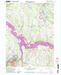
1958 Map of Sharpsville
USGS Topo · Published 1984About this map
The Shenango River Lake dominates this mid-century landscape, a significant water body created along the winding course of the Shenango River. The 1958 topographic survey, updated through the early 1980s, reveals a mix of industrial riverfront development and rural crossroads. In the south, the borough of Sharpsville and the edge of Sharon show dense residential and infrastructure growth near the Conrail rail lines, while further north, smaller settlements like Transfer and Clark sit amidst a network of township roads. Local family and community landmarks are frequent, including Pritchards Corner and Lamonts Corners, alongside spiritual centers such as the Shenango Valley Bible Ch and Bethel Tabernacle. The terrain is marked by the prominent Prospect Ridge and multiple stream valleys, including Pymatuning Creek and Hickory Run, which drain into the central reservoir system.
Find a feature on this map
40 named features on this map. Tap any name to fly to it.
Don’t see what you’re looking for? This feature index may not catch every label — zoom into the map to look around manually.
Map Details
Editions of this 1958 Sharpsville Map
5 editions found
Other maps of this area

1905 · Neshannock
USGS Topo · 1:62,500

1906 · Youngstown
USGS Topo · 1:62,500

1907 · Neshannock
USGS Topo · 1:62,500

1907 · Kinsman
USGS Topo · 1:62,500

1908 · Shenango
USGS Topo · 1:62,500

1908 · Youngstown
USGS Topo · 1:62,500

1950 · Cleveland
USGS Topo · 1:250,000

1954 · Sharon West
USGS Topo · 1:24,000

1956 · Cleveland
USGS Topo · 1:250,000

1958 · Sharpsville
USGS Topo · 1:24,000