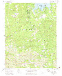
1982 Map of Shaver Lake
USGS Topo · Published 1983About this map
Shaver Lake serves as the central focal point of this high-elevation landscape within the Sierra National Forest. The map documents a transition in the region's economy, where former industrial locations like Matthews Mill (Site), Old Bretz Mill (Site), and Peterson Mill (Site) have given way to recreation and forestry management. These sites, along with the Prescott Mill (Site), reveal the historical footprint of the timber industry that once dominated the area.
Find a feature on this map
48 named features on this map. Tap any name to fly to it.
Don’t see what you’re looking for? This feature index may not catch every label — zoom into the map to look around manually.
Map Details
Editions of this 1982 Shaver Lake Map
2 editions found
Other maps of this area

1904 · Kaiser
USGS Topo · 1:125,000

1922 · Trimmer
USGS Topo · 1:96,000

1924 · Dinuba
USGS Topo · 1:125,000

1942 · Watts Valley
USGS Topo · 1:62,500

1944 · Watts Valley
USGS Topo · 1:62,500

1947 · Mariposa
USGS Topo · 1:250,000

1948 · Fresno
USGS Topo · 1:250,000

1948 · Mariposa
USGS Topo · 1:250,000

1952 · Patterson Mountain
USGS Topo · 1:62,500

1953 · Huntington Lake
USGS Topo · 1:62,500