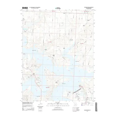
2014 Map of Shawnee Bend
USGS Topo · Published 2014About this map
Harry S Truman Reservoir dominates the landscape west of Warsaw, where the flooded valleys of Clear Cr, Miller Cr, and Flemming Br form a complex shoreline of inlets and peninsulas. This modern survey illustrates the geographical transition between the reservoir and the Lake of the Ozarks to the southeast, separated by the prominent Kaysinger Bluff. The area's older rural character is preserved in the names of numerous hollows, including Stevenson Hollow and Sugarcamp Hollow, alongside a dense network of local roads such as Zion Church Rd and Limestone School Rd. Genealogists will find significant value in the distribution of family and community burial grounds throughout the quadrangle, from Riverside Cemetery near the city to the more secluded Sunnyside Cemetery and Osborn Cemetery. Small landings and settlements like Macks Camp, Racket, and Teal Bend highlight the recreational and residential development tied to the water's edge.
Find a feature on this map
95 named features on this map. Tap any name to fly to it.
Don’t see what you’re looking for? This feature index may not catch every label — zoom into the map to look around manually.
Map Details
Editions of this 2014 Shawnee Bend Map
This is the sole edition of this map. No revisions or reprints were ever made.
Other maps of this area

1887 · Clinton
USGS Topo · 1:125,000

1887 · Warsaw
USGS Topo · 1:125,000

1894 · Warsaw
USGS Topo · 1:125,000

1894 · Clinton
USGS Topo · 1:125,000

1935 · Dell
USGS Topo · 1:24,000

1936 · Shawnee Bend
USGS Topo · 1:24,000

1936 · Schuyler
USGS Topo · 1:24,000

1941 · Valhalla
USGS Topo · 1:24,000

1945 · Fristoe
USGS Topo · 1:62,500
1945 · Valhalla
USGS Topo · 1:24,000