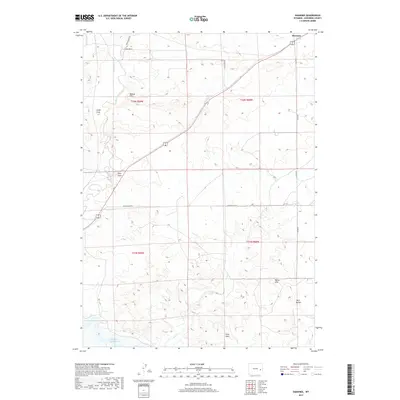
2017 Map of Shawnee
USGS Topo · Published 2017About this map
Shawnee sits at the northern edge of this high-plains landscape, where the confluence of local roads and watercourses marks a quiet corner of Converse County. The terrain is defined by a series of prominent topographic landmarks, from the elevation of Bobcat Hill to the distinct profiles of Twin Buttes and the White Hills. These features provided essential navigational points for early residents in an area where the drainages of Shawnee Cr and Lost Cr dictated the movement of cattle and travelers. In the southwestern portion of the sheet, the waters of Glendo Reservoir reach into the dry draws, illustrating the impact of modern water management on this traditional ranching environment. Local travel is grounded by established routes such as Pickinpaugh Rd and Co Rd 49, which connect isolated homesteads and the various draws, including Cedar Draw and Fero Draw, that fragment the open range.
Find a feature on this map
18 named features on this map. Tap any name to fly to it.
Don’t see what you’re looking for? This feature index may not catch every label — zoom into the map to look around manually.
Map Details
Editions of this 2017 Shawnee Map
This is the sole edition of this map. No revisions or reprints were ever made.
Other maps of this area

1949 · Shawnee
USGS Topo · 1:24,000

1949 · Cedar Hill
USGS Topo · 1:24,000

1949 · Orin
USGS Topo · 1:24,000

1950 · Glendo
USGS Topo · 1:24,000

1950 · Amend Ranch
USGS Topo · 1:24,000

1950 · Orin
USGS Topo · 1:24,000

1950 · Shawnee
USGS Topo · 1:24,000

1950 · Jewel Springs
USGS Topo · 1:24,000
1951 · Cedar Hill
USGS Topo · 1:24,000

1954 · Torrington
USGS Topo · 1:250,000