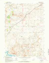
1961 Map of Shawnee
USGS Topo · Published 1965About this map
The Chicago and North Western railroad corridor defines this high plains landscape of Converse County, connecting the small settlement of Shawnee to the rail siding at Fisher. This 1961 field-checked survey preserves the locations of numerous early cattle-country sites, including the Lane Homestead, Nelson Homestead, and Pickinpaugh Homestead. The terrain is characterized by the Grey Hills and White Hills, which roll down toward the North Platte River and the then-recently established Glendo Reservoir. Of significant interest to local historians is the Emigrant Trail, which cuts across the southern portion of the map, tracing the historic route through the drainage of Lost Creek and past the distinctive Twin Buttes.
Find a feature on this map
26 named features on this map. Tap any name to fly to it.
Don’t see what you’re looking for? This feature index may not catch every label — zoom into the map to look around manually.
Map Details
Editions of this 1961 Shawnee Map
This is the sole edition of this map. No revisions or reprints were ever made.
Other maps of this area

1949 · Shawnee
USGS Topo · 1:24,000

1949 · Cedar Hill
USGS Topo · 1:24,000

1949 · Orin
USGS Topo · 1:24,000

1950 · Glendo
USGS Topo · 1:24,000

1950 · Amend Ranch
USGS Topo · 1:24,000

1950 · Orin
USGS Topo · 1:24,000

1950 · Shawnee
USGS Topo · 1:24,000

1950 · Jewel Springs
USGS Topo · 1:24,000
1951 · Cedar Hill
USGS Topo · 1:24,000

1954 · Torrington
USGS Topo · 1:250,000