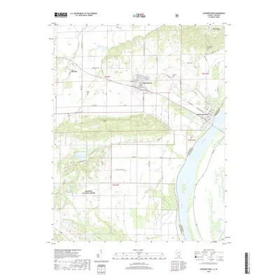
2018 Map of Shawneetown
USGS Topo · Published 2018About this map
Old Shawneetown sits on the banks of the Ohio River, marking a site of deep historical significance at the border of Illinois and Kentucky. This modern survey illustrates the proximity of the original riverfront settlement to the newer site of Shawneetown further inland. The landscape is defined by the sharp transition from the river bottomlands to the prominent elevations of Gold Hill and the Shawneetown Hills, which dominate the northern and central portions of the quadrangle.
Find a feature on this map
78 named features on this map. Tap any name to fly to it.
Don’t see what you’re looking for? This feature index may not catch every label — zoom into the map to look around manually.
Map Details
Editions of this 2018 Shawneetown Map
This is the sole edition of this map. No revisions or reprints were ever made.
Other maps of this area

1905 · Eldorado
USGS Topo · 1:62,500

1905 · New Haven
USGS Topo · 1:62,500

1906 · New Haven
USGS Topo · 1:62,500

1906 · Eldorado
USGS Topo · 1:62,500

1916 · Shawneetown
USGS Topo · 1:62,500

1916 · Equality
USGS Topo · 1:62,500

1949 · Paducah
USGS Topo · 1:250,000

1949 · New Haven
USGS Topo · 1:62,500

1950 · Paducah
USGS Topo · 1:250,000
1953 · Wabash Island
USGS Topo · 1:24,000