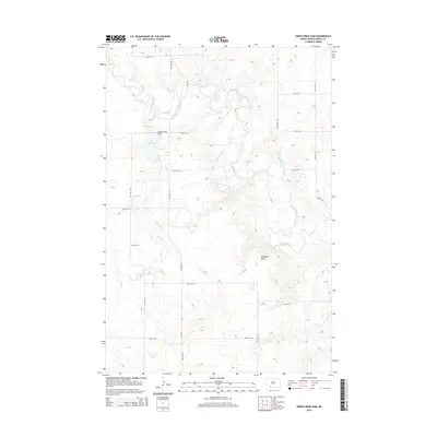
2014 Map of Sheep Creek Dam
USGS Topo · Published 2014About this map
Cannonball River meanders across this rural Grant County landscape, providing the primary drainage for the surrounding prairie. This 2014 survey focuses on the engineering of the Sheep Creek Dam, which impounds Sheep Cr to create a local reservoir. The map reveals a highly structured section-line road grid, with routes like Elgin Rd and 80th St SW defining the agricultural territory. A prominent natural landmark, Medicine Rock, stands out as a distinct geological feature amidst the uniform elevation contours. The area remains sparsely populated, dominated by the intersection of water management and traditional plains topography, where the river's winding course contrasts with the rigid geometry of the regional road network.
Find a feature on this map
20 named features on this map. Tap any name to fly to it.
Don’t see what you’re looking for? This feature index may not catch every label — zoom into the map to look around manually.
Map Details
Editions of this 2014 Sheep Creek Dam Map
This is the sole edition of this map. No revisions or reprints were ever made.
Other maps of this area

1954 · Bismarck
USGS Topo · 1:250,000

1958 · Bismarck
USGS Topo · 1:250,000

1972 · Leith
USGS Topo · 1:24,000

1972 · Wheeler Hills
USGS Topo · 1:24,000

1972 · Coffin Buttes
USGS Topo · 1:24,000

1972 · New Leipzig South
USGS Topo · 1:24,000

1972 · Pretty Rock Butte
USGS Topo · 1:24,000

1972 · Sheep Creek Dam
USGS Topo · 1:24,000

1980 · Heil
USGS Topo · 1:24,000
1980 · Elgin
USGS Topo · 1:24,000