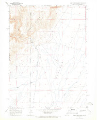
1965 Map of Sheep Creek Range SE
USGS Topo · Published 1991About this map
Sheep Range elevations define the western edge of this Nevada landscape, where the high ground drops sharply into the expansive Boulder Valley. This mid-1960s survey captures a transition between the rocky ridges of the range and the lower alluvial reaches of Boulder Flat to the southeast. Hydrological data collection is evident along the drainage of Rock Creek, where a Gaging Station monitors flow patterns through this arid basin.
Find a feature on this map
9 named features on this map. Tap any name to fly to it.
Don’t see what you’re looking for? This feature index may not catch every label — zoom into the map to look around manually.
Map Details
Editions of this 1965 Sheep Creek Range SE Map
2 editions found
Other maps of this area

1955 · Winnemucca
USGS Topo · 1:250,000

1957 · Dunphy
USGS Topo · 1:62,500

1957 · Beowawe
USGS Topo · 1:62,500

1958 · Winnemucca
USGS Topo · 1:250,000

1962 · Winnemucca
USGS Topo · 1:250,000

1965 · Sheep Creek Range SW
USGS Topo · 1:24,000

1965 · Sheep Creek Range NE
USGS Topo · 1:24,000

1965 · Sheep Creek Range SE
USGS Topo · 1:24,000

1965 · Sheep Creek Range NW
USGS Topo · 1:24,000

1968 · Rodeo Creek SW
USGS Topo · 1:24,000