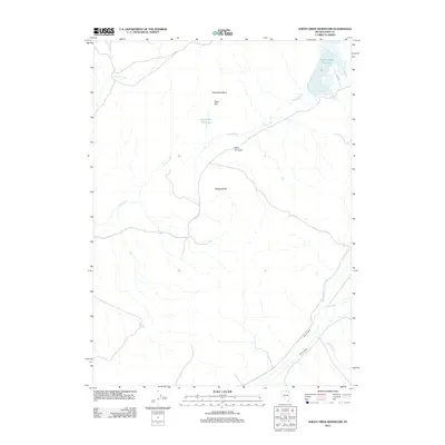
2012 Map of Sheep Creek Reservoir
USGS Topo · Published 2012About this map
Sheep Creek Reservoir dominates the northeastern corner of this high-desert landscape in Elko County, serving as a primary water management feature in an area defined by seasonal drainages. The hydrology of the region is traced through the winding path of Sheep Creek, which connects several topographic and man-made landmarks, including the notable Horseshoe Bend and the small Poker Flat Reservoir. The terrain around Poker Flat is relatively open, marked by specific points of access like the Poker Flat Gate. In the southern half of the quadrangle, the elevation rises toward Sugarloaf Hill, while the drainage network expands to include Dry Creek, Silver Creek, and Spring Creek. This 2012 survey illustrates a sparsely settled portion of Nevada where land use is dictated by water access and the physical relief of the Great Basin.
Find a feature on this map
12 named features on this map. Tap any name to fly to it.
Don’t see what you’re looking for? This feature index may not catch every label — zoom into the map to look around manually.
Map Details
Editions of this 2012 Sheep Creek Reservoir Map
This is the sole edition of this map. No revisions or reprints were ever made.
Other maps of this area

1939 · Owyhee
USGS Topo · 1:62,500

1942 · Owyhee
USGS Topo · 1:62,500

1955 · McDermitt
USGS Topo · 1:250,000

1956 · Bull Run
USGS Topo · 1:62,500

1959 · McDermitt
USGS Topo · 1:250,000

1964 · Hat Peak
USGS Topo · 1:62,500

1964 · Wilson Reservoir
USGS Topo · 1:62,500
1971 · The Point
USGS Topo · 1:24,000
1971 · Dry Creek Reservoir
USGS Topo · 1:24,000

1982 · Bull Run Mts
USGS Topo · 1:100,000